
The Bay of Bengal (BoB) is a semi-enclosed sea located in the northeastern part of the Indian Ocean, bordered by India, Bangladesh, and Myanmar. It is an important region for climate research due to its influence on the Indian monsoon and its potential to generate severe weather events, such as tropical cyclones. The sea surface temperature (SST) of the Bay of Bengal plays a crucial role in these processes and is therefore of great interest to scientists and policymakers alike.
SST in the Bay of Bengal has increased steadily over the past several decades, reflecting the overall trend of global warming. This increase in SST has been linked to several climate impacts, such as changes in the Indian monsoon and increased frequency of extreme weather events. It is important to continue monitoring SST in the Bay of Bengal to better understand these impacts and prepare for future changes.
The Indian monsoon is a critical feature of the Bay of Bengal region, providing much-needed rainfall to support agriculture and water resources. SST in the Bay of Bengal has been shown to impact the strength and timing of the monsoon, which can have significant impacts on regional water resources and food security. In addition to affecting the monsoon, high SST in the Bay of Bengal can also increase the likelihood of severe weather events, such as tropical cyclones. Higher SST provides more energy for these storms to form and intensify, potentially leading to greater impacts on coastal communities.
The analysis titled "Time Series Analysis of Data for Sea Surface Temperature (SST)" by Shanto Khandoker from the Department of Oceanography & Hydrography at BSMRMU, focuses on the use of time series analysis to study the changes in sea surface temperature on Bay of Bengal. The analysis uses data on SST from 1920 to 2020 to understand patterns and trends in the temperature of the BoB ocean's surface. The study is used NOAA Extended Reconstrued Sea Surface Temperature (ERSST), version 5 data from the website Click Here. The SST data is available at NetCDF format from 1856-present.
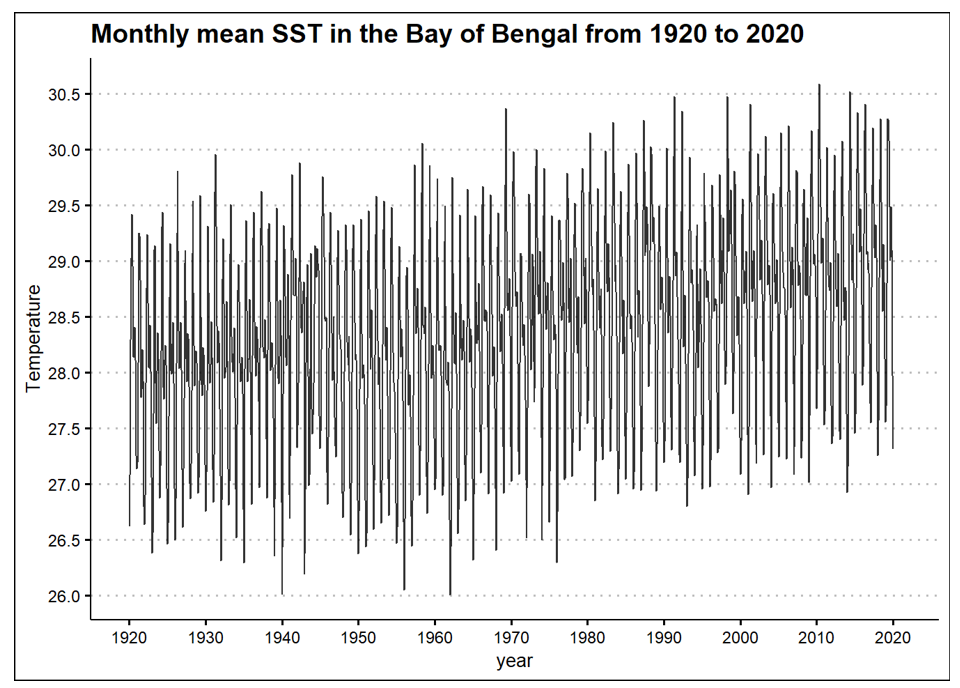 Figure 1: Time Series plot of SST in Bay of Bengal (1920-2020).
Projections of future SST in the Bay of Bengal suggest that the region will continue to experience warming, with the potential for significant impacts on the monsoon and severe weather patterns. It is important to continue monitoring SST in the Bay of Bengal and understand how these changes may impact the region in the future.
There are several satellites and data sources used for monitoring sea surface temperature (SST) in the Bay of Bengal and around the world. Some of the most commonly used sources include:
In addition to satellite data, SST measurements are also taken from in situ observations, such as buoys and ships, which can provide higher-resolution and more localized data. These satellite and in situ data sources are combined to provide a comprehensive view of SST conditions in the Bay of Bengal and around the world.
The sea surface temperature of the Bay of Bengal plays a critical role in the region's climate and weather patterns. Monitoring and understanding changes in SST is crucial for predicting and preparing for future impacts, such as changes in the Indian monsoon and increased frequency of severe weather events. By staying informed on the current and future state of SST in the Bay of Bengal, we can work to ensure a more resilient and sustainable future for the region and its communities.