
Most of Bangladesh lies in the delta of three of the largest rivers in the world- with low and flat topography. Bangladesh is susceptible to 4 types of floods. About 20% of its area is inundated by overflowing rivers during monsoon in a normal flood year, about 35% in a moderate flood year, and more than 60% in a major flood year (CCC, 2009). Flooding in Bangladesh is the result of a complex set of factors- huge inflow of water from upstream catchment areas coinciding with heavy monsoon rainfall, low floodplain and congested drainage channels, convergences of the major rivers inside Bangladesh, sudden high intensity rainfall, tides and storm surges in coastal areas and polders that increase the intensity of floodwater outside protected areas (Ahmed, 2006).
Urban Flood Vulnerability and Disaster Risk
The effects of climate change, including intensified rainfall and greater frequency of extreme weather events, coupled with unplanned, rapid urbanization extending into the floodplains, are expected to aggravate Dhaka’s vulnerability to flooding (UNFCCC 2008; World Bank 2010; WWF 2009). The climate of South Asia is changing: the frequency of heavy-rainfall events is increasing, while light-rainfall events are decreasing (IPCC 2013). In the coming decades, all climate models and scenarios are predicting an increase in South Asia’s average and extreme rainfall during the summer monsoon (IPCC 2014). Regarding seasonality, climate model agreement is high on an earlier onset and later retreat and thus longer duration of the summer monsoon. For tropical cyclones making landfall in South Asia, model agreement indicates that rainfall will likely be more extreme near the centers of such systems (IPCC 2013). On the whole, scientific evidence to date predicts high flood risk for low-lying areas in Bangladesh in a changing climate; and Dhaka has been identified as one of the top Asian cities in terms of population exposure to flooding by the 2070s (Hanson et al. 2011; IPCC 2014)
Table: Different types of flood, Causes and Time of occurrence in Bangladesh
Types of Flood | Causes of occurrence | Time/ duration | Tentative affected area |
Flash Flood | Run-off due to heavy rainfall in neighboring upland areas | April and May | North-east parts of Bangladesh |
Rainwater / Monsoon Flood | Heavy rainfall over flood plain and terrace areas | April-May June-August | South-western part of the country |
River Flood | Snow melting in Himalayans, heavy monsoon rainfalls over the Himalayans, the Asam Hills, the Tripura Hills and the Upper Brahmaputra and Ganges flood plains | April-May and June- September | Catchment areas of three major rivers |
Coastal Flood | Storm surge due to cyclone and tidal surge induced flooding | June - September | South western coastal areas |
Source: NAPA 2009 (Ahmed, 2006)
Table: Impact of major floods (in last 50 years)
Events | Impact |
1954 floods | Affected 55% of the country |
1974 flood | Moderately severe, over 2,000 deaths, affected 58% of country, followed by famine with over 30,000 deaths |
1984 flood | Inundated 52,520 sq-km, cost estimated at US$378 million |
1987 flood | Inundated over 50,000 sq-km, estimated damage US$ 1.0 billion, 2055 deaths |
1988 flood | Inundated 61% of country, estimated damage US$ 1.2 billion, more than 45 million homeless, between 2,000-6,500 deaths |
1998 flood | 1,100 deaths, inundated nearly 100,000 sq-km, rendered 30 million people homeless, damaged 500,000 homes, heavy loss to infrastructure, estimated dam- age US$ 2.8 billion |
2004 flood | Inundation 38%, damage US$ 6.6 billion, deaths 700, affected people nearly 3.8 million |
2007 flood | Inundated 32,000 sq. km, over 85,000 houses destroyed and almost 1 million damaged, approximately 1.2 million acres of crops destroyed or partially dam- aged, estimated damage over $1 billion, 649 deaths |
2008 flood | Inundated 3,394 sq. km, fully damaged houses is 11,448, approximately 0.35 million acres of crops destroyed or partially damaged |
2013 flood | In northern Bangladesh, 133 villages of 40 unions in Thakurgaon have been flooded due to overflowing of the rivers, affected 35,000 household and killed 5 persons. |
2016 flood | One of the most devastated flood in recent history, under reported. An estimated 1.9 million people have been affected by flooding across 19 districts of Bangladesh, with a death toll of 14. |
2017 flood | Widespread flooding has killed 145 people, affected 8 million people across 32 districts, destroyed 103,855 houses, and damaged 4,636 education infrastructure. the priority concerns of flood-affected communities were food security, livelihood and shelter. In the flood-affected areas, most of the crop lands has been submerged for at least 5-7 days causing damage to crops, houses, infrastructures. Most of the houses are made of mud and straw and they have been fully damaged. |
2019 flood | 7.6 million persons in 28 districts are affected by the monsoon floods. More than half a million houses were damaged or destroyed and 300,000 persons were displaced. Approximately 584,000 houses are damaged or destroyed, while flooding has damaged transport infrastructure, including 6,641 kilometers of road and 1,275 bridges. The number of deaths remain at 119. |
2020 flood | Flooding in 30 districts in the north, north-east and south-east of the country, 24% of the country is inundated, affecting some 5.4 million people. More than 1.27 million houses have been partially or fully damaged by the floods and over 167,000 families remain displaced. In addition, over 170,000 hectares of agricultural land have been affected. floods resulted in over 220 deaths. More than 150,000 ha of paddy fields were damaged, along with thousands of latrines and tube wells. Over 1,900 schools are damaged, leaving 807,467 children without access to education. |
2021 flood | Heavy rainfall has caused flooding in northern Bangladesh. More than 40,000 households were affected, 7759 hectares of agricultural land have been damaged, and more than 200 houses have been destroyed |
Source: NAPA 2009 (NAPA 2005, MoEF 2009, and DMB, 2008, https://reliefweb.int/
https://reliefweb.int/
Climate change will increase flooding intensity and damage over the country. It is estimated that the peak monsoon inflows from the Ganges and Brahmaputra will increase 10% and 5%, respectively, by 2080. This increase, in combination with an expected sea-level rise of 1.2 meters will cause longer, more widespread floods with increased flood levels; coastal area may be inundated by 60cm more than 1998 flooding (Kafi and Chowdhury, 2010).
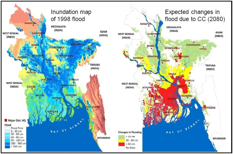
Figure: Change in inundation between 1998 flood and 2080 flood (projected considering climate change) (source: IWM)
References